Where is Hong Kong?
Where is Hong Kong on the map?
Hong Kong is located on the southern coast of China. The west of the city is the Pearl River estuary. The east and the south of it face the South China Sea. The north of it borders the Guangdong city of Shenzhen with the Shenzhen River in between.
Hong Kong Map

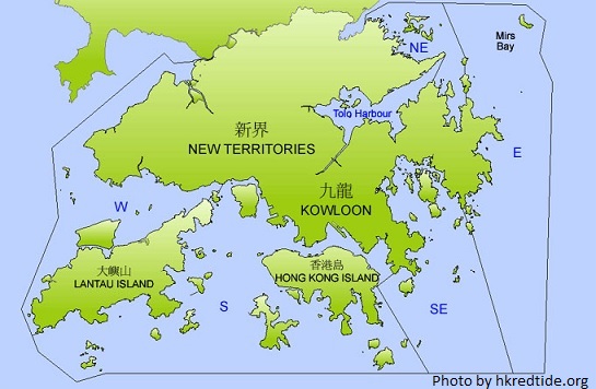
Hong Kong consists of three main regions: Hong Kong Island, Kowloon and the New Territories. Some people may think that only Hong Kong Island is called “Hong Kong”, but it is a “no”. Hong Kong Island is the second largest island of the city, while the largest one is Lantau Island which belongs to the New Territories. Hong Kong Island is separated from Kowloon Peninsula and the New Territories by Victoria Harbour.
Map of Hong Kong
Is Hong Kong a country
Hong Kong Island was the first region of the city that was ceded to the British Empire by the Qing Government of China in 1842 after its defeat in the First Opium War; Kowloon was ceded later in 1860, and the New Territories was leased for 99 years in 1898. Maybe that’s why some people have an impression that Hong Kong only refers to Hong Kong Island.
Hong Kong was a British colony since 1842 until the handover of it to the People’s Republic of China on 1 July 1997 and became China’s first Special Administrative Region.
Thank you for reading this post. Feel free to get in touch if you have any questions or comments. Please like us on Facebook and share our posts.
To subscribe for free newsletter and updates from Hong Kong Travel Guide in your inbox, simply sign up at the right-handed sidebar.
Related Posts


About The Author
Katy
Katy Yam is the founder and editor of Hong Kong Travel Blog | Hong Kong Travel Guide. You can read more about her in About This Blog and connect with her on Facebook, Twitter and Pinterest.
Hi, Neat post. There is an issue along with your
site in internet explorer, might check this?
IE nonetheless is the market leader and a huge section of other folks will omit your magnificent
writing due to this problem.
Thanks for your comments. I will figure out that IE problem.
It’s actually a cool and useful piece of information. I am happy that you simply shared this useful info with us. Please stay us up to date like this. Thank you for sharing.|
Sure, thank you.